Sunday, January 30, 2011

Attractions in Toora & Wilsons Promontory National Park

Day started off very hot...so we got underway early for a change....


First stop we drove up to see the Wind Farm... amazing... and the views from up there wow !!!


These twelve turbines were manufactured in Denmark and provide a total output of 21 megawatts - sufficient to power 6600 homes, cutting greenhouse emissions by 48 000 tonnes per year. The towers are manufactured in Bendigo. They are 67 metres in height, they weigh 117 tonnes and are each set in 600 tonnes of reinforced concrete. The blades of the rotor are 33 metres in length, made of reinforced plastic and carbon fibre,  sensors read the wind speed and direction and  feed the information into a computerised system. They also possess a yaw mechanism to turn the rotors in the direction of the wind. Absolutely amazing they are...


AGNUS FALLS

From there we drove to Agnus Falls which are one of the highest waterfalls in Victoria. At the Falls Reserve the river plunges 60 m into the gorge. The damming of the river above the falls has ensured a regular water supply to Welshpool and other local towns.
We then drove into town and checked out some of the really old buildings...the town as 10, here is a picture of one of them the old bank building..


The heat is around 36 degrees and much to our disappointment its too hot to put the top down..as we now decided to go for a drive to Wilsons Promontory which is about 70 ks away.. a great drive through the country side...We stopped off at Foster and had a pie for lunch..

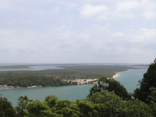
A different view of the turbines with a water view.....every corner you turn there is a beautiful view


WILSONS PROMONTORY

Wilsons Promontory National Park has an early history of Aboriginal occupation with archaeological records dating back at least 6500 years. The Prom had (and still has) spiritual significance for different Aboriginal groups, who knew the area as Yiruk or Wamoom. The area as a valuable food source, particularly in summer. Aboriginal people may have used the Prom, which was then part of a 'land bridge', to reach Tasmania during past Ice Ages.

Today, local Aboriginal communities are active in establishing cultural and spiritual links with the park and in undertaking park management activities.
 
George Bass and Matthew Flinders were probably the first Europeans to see the Prom, on their 1798 voyage from Sydney, and Bass is thought to have named it after a London friend of Flinders'. They recognised its commercial value, as the name Sealers Cove shows; commercial exploitation of seals, whales and timber, and for cattle grazing, went on for nearly a hundred years.
 
The Prom's position means that it is important for navigation in the turbulent waters of Bass Strait, and a lighthouse was built on South East Point in 1859.
 
Following campaigns by the Field Naturalists Club of Victoria, and lobbying by the Royal Society of Victoria, the Victorian government temporarily reserved most of the Promontory as a national park in 1898. Permanent reservation followed in 1908, although the Yanakie area north of the Darby River was not added until the 1960s. A chalet for visitors was built at Darby River, but for many years a trip to the Prom was quite an adventure, involving a boat trip across Corner Inlet and a horse ride, or a car drive along the beach, with the risk of being swamped by waves! The main entrance road was not completed until the 1930s.
 
During World War II the Prom was used for commando training and was closed to the public. Army buildings at Tidal River formed the nucleus of a post-war holiday village that gradually developed as more people came to the Prom. The entrance road was sealed in 1970-71 with visitor numbers increasing steadily.

Its the southernmost point of the Australian mainland, Wilsons Promontory (affectionately known to Victorians as 'the Prom') is the most loved national park in Victoria. Its 130 km coastline is framed by granite headlands, mountains, forests and fern gullies.
 Once we passed into the national park we headed to Tidal River, 30 km inside the park boundary, stopping off to look at some spectacular views on the way.


We were amazed when we got down to Tidal River and the size of it....It has some 450 camping and caravan sites.... it is perfectly situated near the beach and the river. The campsites are in great demand and bookings are required for all holiday periods. A ballot is held to allocate sites over the popular summer season. We would not be able to go there though as no room for big rigs... 

Lots of places to walk and check out the sites but it was SO !! hot..

We headed back and stopped off at a few different high spots and beaches..Squeaky beach was just beautiful...

Squeaky Beach is one of the more accessible beaches of the Prom, although the access path has some obstacles such as sand and moderate slopes... you had to walk 300 metres to the beginning of the beach...and in the heat was pretty hard for me..but I didnt want to miss out on some of these lovely places...


The sand was so white ...as you can see by the reflection in these pictures...

After this we headed home... to relax in the a/c of the RV...
What a day !!!

Saturday, January 29, 2011

Torra

On our way just after 10am...After looking up some camp sites we decided to head to a place called Woodside Beach..once again the owners assuring us they could fit a 10 metre RV in ...when we got there we found this not to be true... gawdddd how many more times... plus the place was a dump...and they wanted to charge $38 night and no water ( they only had bore water) which she forgot to tell us when we booked...We looked this Park up on the internet as we do everytime before we ring and it looked great..it really disheartens you..when it keeps happening...

Anyway enough whinging... we moved on...I got the computer out and we travelled on a bit more to a place called Torra just outside Yurram...tiny town...They managed to fit us in...Thank goodness as John was getting tired of driving we had been on the road about 4 hours...

Torra is a small picturesque dairy town in Western Gippsland it is located 197 kilometres south-east of Melbourne, it is a small town surrounded by undulating hills which are primarily used for dairying. The word 'toora' is said to be an Aboriginal instruction which translates as 'woman, look after fire'. It was reputedly used regularly when the men in the group departed for religious ceremonies at Wilsons Promontory.

Toora was originally known as Muddy Creek. The township's early economic prosperity was based around a timber mill until the 1870s. This was partly ensured by a contract with the Indian government to produce railway sleepers. The sleepers were made at Toora and conveyed to offshore ships by barges. Remnants of the loading facilities and tramlines can still be seen.

The original settlement  was located to the west of the present townsite. A post office opened there in 1882. The new site for Toora was subdivided in 1888 after one of the largest tin mines Victoria has had began operations that same year.  A huge hole in the ground, now obscured by plant life was created by hydraulic sluicing operations which transported water from the Dingo and Agnes Creeks to the mines. Excavations stopped in the 1930s during the Great Depression and it never reopened.

Tomorrow we plan on exploring around the area see what we can find..

Friday 28th Jan

John got a good report from the doctors thank goodness all his blood test came back normal...Doctor seems to think its one of his medications that may be causing the bruising so John will cease taking it and we will see what happens....


Day at home today John cleaned the car and all the little acorns that landed on the roof of the RV.....

 and packed up out side .....I did all the washing and packed up inside ready to leave tomorrow...

Thursday, January 27, 2011

Comments

Please feel free to leave a comment at anything you have read...all you have to do is click on the "comment" at the bottom of the page after each day... Thanks love to hear from you and your comments on the blog !!

Visit to Bainsdale & Metung

Today was a good day weather wise...25 degrees perfect...for our lovely drives, decided to go into Bainsdale today as we had to go to Medicare...

Bainsdale is 30 klms out of Lakes Entrance it is the largest city in the East Gippsland region, situated on the Mitchell River which then flows into the extensive Gippsland Lakes system at Lake King.

Bairnsdale's large and busy commercial centre is built around the Princes Highway which opens up into a wide boulevard featuring trees, gardens and a rotunda in the central strip. Landmarks in the commercial centre include the impressive St Mary's Catholic Church (built between 1913 and 1937), the courthouse in Nicholson Street (1894), the town's water tower, and a number of historic shops and hotels.
 
After having a walk around the shops etc..and lunch at Subway we headed back home, on the way back we decided to go check out Metung ....it is a small Village of 1000 permanent residents located on a narrow peninsula of land seperating Bancroft Bay and Lake King. It is situated in East Gippsland and ideally placed with the surrounding protected waters of the Gippsland Lakes (400 sq Kilometers)

The main activities are boating and fishing, but Metung is also known for it's scenic walks.


We thought  it was just beautiful, and like all our others days of exploring this great area we are amazed at what we find by just driving down a country road a few kilometers.

Finished off the day with a bbq .... John has come out with another big bruise...I will be glad when tomorrow comes and hopefully find out whats causing them as he has to go back to doctors for his blood results...

Wednesday 26th Jan

Strange weather down here we have one good day and one dull day.. rained again last night, and been dull for most of the day... we didnt do too much today, went and had a nice late lunch at the Bowling Club, then came home and watched the tennis for the rest of the day....My poor man was sick and lost poor Nadel ...

Tuesday, January 25, 2011

Seaview Drive

Glorious day today, John was up early as he had to drop the car at the Auto Electricians to be wired up for our new trailer, then he had a doctors appointment...he keeps coming out in bruises everywhere, and its not from me beating him up :)..so the doctor has taken some blood for tests, he goes back friday for the results...speaking of bruises I woke up with this one this morning and I have no idea how I got it.....


After lunch we went for yet another drive to check out another lookout ..the views are amazing of this place..the water ways are just glorious no wonder every second person here has a boat.. wish we had ours here :(

However, for one of the best views of the area, we drove along the appropriately named Seaview Parade  with unparalleled views over the town centre, marinas, Cunninghame Arm and down to the Ninety Mile Beach.

As a holiday town with a large emphasis on water activities and a high concentration of marinas and jetties along its extensive lake coastline, it is no surprise that Lakes Entrance is the base of one of Australia's largest fishing fleets. The Fisherman's Co-Op, located on Bullock island, sells a wide variety of freshly caught fish to the public, as we sampled for dinner the other night...


Then  we went back into town and parked the car and went for a walk across the popular landmark footbridge, which crosses Cunninghame Arm, links the town centre with the sand dunes and windswept coastline of Bass Strait.


 View of bridge from town
 Ninety Mile Beach
View of bridge from beach

 A 5 kilometre return walk from the footbridge along the narrow peninsula of land which separates the still waters of Cunninghame Arm from the choppy waters of Bass Strait takes you along some scenic coastline and coastal bush to the Flagstaff Lookout which provides good views over the man-made entrance into the Gippsland Lakes, but of course we didnt do that :) Just wish I was fit enough though....

Monday, January 24, 2011

Monday 24th Jan

Once again we had heavy rain over night... seems to be the pattern here, it rained till mid morning then blue skies opened up it was a windy day but a nice day...

Had a day at home today after going to post office and picking up my parcels I came back and worked on the blog to catch up on the last week I had not posted so hope you all enjoyed my efforts...

HAPPY BIRTHDAY JOHN !!!! Sunday 23rd Jan

Boy did we have a storm and rain last night... poured for hours... but we woke to beautiful sunshine so didn’t take long to dry every thing out again.
We had a nice sleep in..John's day so he gets to do what he wants :)
After a late breakfast... we decided to go for a drive...hood down beautiful day we headed back East towards Orbust and check out some of the tourist points along the way...
First turn off was Bunga Point the beaches are just lovely around here


Then we moved on to Lake Tyers which is around 10 kilometres east of Lakes Entrance it is just a small community
Lake Tyers opens out into the ocean on the Ninety Mile Beach, you can enjoy bushwalking, fishing, boating, swimming they have a  waterfront tavern where you can get a meal or drink.


Local surfers usually trek down to Red Bluff - a stretch of ocean beach located beneath a rocky headland within walking distance of the lake's sea entrance. You can see water every where you look its just beautiful..

They have 2 caravan parks in this area we went for a drive through  them but they have a lot of trees and hard for us to get in them...
Drove back home and had a late lunch, then went out to buy John his birthday present, a new electric razor.

A birthday kiss

We had a walk around the esplanade again and checked out the sand sculptors

Saturday 22nd Jan


We went for a nice walk on the foreshores this morning, the place is a buzz with holiday makers..checked out all the fishing boats, and we bought a kilo of king prawns straight off the boat freshly caught this morning... we had them for dinner with salad...yummm


After lunch we went for a drive around and checked out some of the local lookouts..over looking the water ways.
A number of lookouts provide panoramic views over Lakes Entrance and the surrounding waterways, with most located on or near the Princes Highway, just west of the town in the neighbouring community of Kalimna.


Friday 21st Jan

Woke up really early and I mean really early for us .. 6am !!!!!!!!!! gawd.....but we wanted to be on the road early .. heading for Lakes Entrance can not wait to get there and set up for a while and stay put and no more hassles....
Lakes Entrance is situated between Bairnsdale and Orbost at a man-made channel that links Bass Strait and the Tasman Sea with the 400 square kilometre network of inland waterways known as the Gippsland Lakes.
As a water-front town, Lakes Entrance is a very popular all year round holiday destination, including during winter months when the climate is often a few degrees warmer than Melbourne. The main thoroughfare of the Esplanade runs along the shoreline of the Cunninghame Arm inlet, with marinas and attractive foreshore gardens on one side, and a good selection of shops, restaurants and accommodation options on the other side.

Still more winding roads though and plenty of narrow bridges...

We had a nice drive stopping for morning tea on the way...After finding the Caravan Park...Koonwarra Family Holiday Park and set up we then went into the main shopping centre which was just down the road to get some groceries..and came back and finished setting up..I  did my washing and it was nice to just sit and relax..Been a beautiful  day today around 27 degrees...nice sunset... and a lovely balmy night... perfect !!!

Thursday 20th Jan

Up bright and early today...the guy picked up the trailer on time and it was not upsetting to see it go...We packed up then and left the park as we had to be out by 10am... We were not able to pick up the new trailer till 2pm... so we drove over to his property and hung around there till it was all finalised.  John was give a demo of how to load the car and off we went...


It was about 3pm and we are heading towards Cann River an hour and fourty minute drive... we plan on just finding a free camp tonight...We had a good drive and have now crossed the border into Victoria... the roads were sometime very narrow for a highway and we passed many narrow bridges..I was freaking out but the worst was a one way WOODEN bridge, I was thinking how on earth is it going to take this 10 tonn RV plus car and trailer... all along people were fishing on the bridge, and it was that narrow they had to breath in Im sure for us to pass....grrrrr I hate bridges...


We arrived around 5pm found a spot on the side of the road.. and settled down for the night... along with the march flies....1000's of them aarrrggggggghhhhhh


The trailer travelled well John was very pleased....